Webb County
- Coordinates
- 27° 46' 12" N, 99° 19' 48" W 27.77, -99.33
- State
- Texas
- Region
- South
- County Seat:
- Laredo
- Year Organized:
- 1848
- Total Square Miles:
-
3375.589
3,361 square miles (8,700 km2) land
14 square miles (36 km2) water - Population:
-
274794 (2017)
Population: 271,193 est. (2016) 250,304 (2010) - Persons/Square Mile:
- 81
- Webb County Website
- http://www.webbcountytx.gov/
Contiguous Counties
La Salle (N)Duval (Eeast)
Jim Hogg (SE)
Zapata (S)
Maverick (NW)
Webb County Offices
County structure
- Government Type:
- County
- Authority:
- Dillon's Rule
- Legislative Body:
- Commisioners Court
- Size of Legislative Body:
- 5
Demographics
- 2018 Population:
- 274794
- 25 to 64 Years of Age:
- 46.32%
- 65 Years of Age and Older:
- 9.45%
Economy, 2018
- Gross Domestic Product (GDP):
- $12.4 B
- Labor Force:
- 116,573
- Unemployment Rate:
- 3.80%
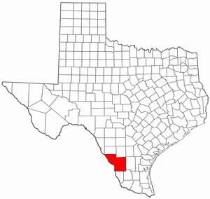
Webb County is located in the southernmost portion of the state. It is situated near the Mexican border. Laredo, the county’s seat, is located in the southwest portion of the county at the intersection of Interstate 35 and US Highway 59. The county’s geographic center is located at latitude 27°45′ N and longitude 99°20′ W.
Grass, mesquite, prickly plants, and cactus dominate the bulk of Webb County. Three thousand three hundred sixty-three square miles make up Webb County. Clay and loam predominate at elevations ranging from 400 to 700 feet. The Nueces River is formed by smaller tributaries that flow south from the north, east, and west. The Rio Grande borders the southern and western reaches of the state.
Many naturally occurring minerals found on the earth are the clay, uranium, oil, natural gas, and zeolite. In July, temperatures might reach a maximum of 100 degrees Fahrenheit (38 degrees Celsius). In January, temperatures can fall as low as 43 degrees Fahrenheit. The growing season lasts 314 days and receives around 20 inches of rain each year.
Economic Activity
According to the US Federal Reserve, Webb County, Texas had a population of 277.68100 people in January 2020, whereas there were 72.85900 people in January 1970. This is the first time since January 2022 that the Federal Reserve has updated population figures for Webb County, Texas. Trading Economics has the most recent data on Webb County, Texas’s Resident Population, and forecasts for the future.
It is estimated that in Webb County, Texas, there were 8,50% unemployed people as of January 2020. Unemployment in the county has fluctuated dramatically since the beginning of time. From 15.60 to 3.70 in January 1995, it dropped significantly. The last time the unemployment rate in Webb County, Texas, was updated was in January of 2022. Data and estimates on Webb County, Texas’s percent unemployment rate are provided by the Federal Reserve Bank of the United States to Trading Economics.
An economic boom in Webb County, Texas, is one of the quickest in the state. Many people choose to commute to larger metropolitan areas by car for work. People who live in this area can still find jobs.
To live more sustainably, residents turn to alternative energy sources. They do not rely on coal-fired power. Instead, they rely on the sun for their energy. As a result, they consume less water and recycle their materials.
Webb County is a popular location for new businesses because of the minimal overhead costs associated with doing business there. Aside from that, it’s true that certain firms offer incentives to new residents. The county government also provides a wide range of services to aid business development.
Mines and oil wells can be found all over the place. People in Webb County can find work in these fields.
Politics
Even though Webb County is located in a Republican-leaning state, it has many Democrats. That’s how it’s always been since the first time the legislation was passed, in 1916. In 1912, only William Howard Taft remained in the race for the Republican nomination for president. Even though Texas had backed John McCain in the last presidential election, 71% of Webb County, Texas voters chose Barack Obama over John McCain. With 13,111 votes, McCain came in second place in Webb County (28 percent ). Democratic presidential candidate John Kerry was defeated in the 2004 election by Barack Obama. Obama garnered 63% of the vote in Texas, while Kerry received 50%. In Webb County, Kerry received 23,654 votes or 57% of the vote. Bush received 17.753 percent of the vote in the same county (42 percent ).
Despite the state’s persistent Republican lean, Webb County chose Barack Obama over Mitt Romney as its 2012 presidential nominee. In 2008 and 2012, Webb County supported Democratic Senate candidates. The challenge to Republican John Cornyn by Rick Noriega was unsuccessful. Kay Bailey Hutchison’s successor Paul Sadler was beaten by Senator Ted Cruz in the Republican primaries.
County Offices
The Honorable Tano E. Tijerina is the county judge and is available via phone (956) 523-4600 / (956) 523-5065.
The District Attorney Honorable Isidro R. Alaniz is available via (956) 523-4900 / (956) 523-5054.
Marco Montemayor heads the county attorney’s office, and contacts are (956) 523-4044 / (956) 523-5005.
Esther Degollado is the district clerk, and you may reach out via (956) 523-4268 / (956) 523-5063.
The County Clerk’s office, headed by Margie R. Ibarra, is available through (956) 523-4251 / (956) 523-5035.
Martin Cuellar is the sheriff in town, and contacts include (956) 523-4500 / (956) 523-5067.
Places To Visit
St. Augustine Plaza, Laredo
The town of St. Augustine was founded in 1755, and St. Augustine Plaza is located in the heart of the city. It was accompanied by the flags of all six Texas states. The Republic of the Rio Grande, which attempted to separate from Mexico’s Republic in 1840, flew its flag as the country’s sixth. South of the square is the Republic of the Rio Grande’s capital, which was constructed as a museum. Visitors are welcome at the museum. Because of Confederate officer Col. Santos Benavides’ headquarters in St. Augustine’s during the Civil War, the city saw a great deal of fighting. John Z. Leyendecker, Leyendecker’s brother-in-law, may be found on the plaza’s western edge. Almost all of the battle took place in and around the plaza, except a few Confederate troops. In late 1863 and early 1864, Laredo had a successful year. The United States of America acquired the Lower Rio Grande Valley. These were “cotton times” for the people of Laredo. The Union army attempted to burn 5,000 bales of cotton in March 1864. With cotton bales, Benavides and his troops constructed defensive positions on the buildings surrounding the plaza. Although there were few trees in St. Augustine’s when Benavides fought, he hung two horse thieves. A plaque in the plaza honors Santos, Refugio, and Cristobal Benavides.
The Republic of the Río Grande Museum
As the oldest building in Laredo, the Republic of the Rio Grande Museum is located here. San Agustin Plaza in downtown Laredo is home to this well-kept secret. When it was initially constructed in 1830, the museum was somewhat tiny. 1860 was the year it was first extended, and it has continued to grow ever since. Once upon a time, Laredo was home to a well-known rancher and mayor. Contrary to popular belief, the Rio Grande Republic’s capital was housed in this building in 1840. As a consequence of this recognition, the Museum has been recognized as a historic home museum.
A historic structure in the San Agustin area has been designated as a Texas Historic Landmark. The museum forms a triangle with two of the city’s most well-known historic landmarks, the La Posada Hotel and the San Agustin Cathedral.